El Niño and La Niña: How a Pacific Seesaw Changes Weather Worldwide
Every few years the tropical Pacific tilts, and the whole planet feels it. Rainfall that belongs to one continent falls on another; fisheries collapse and recover; harvests fail thousands of kilometers from the ocean involved. The mechanism has a name most people know and few can explain: El Niño.
The normal state
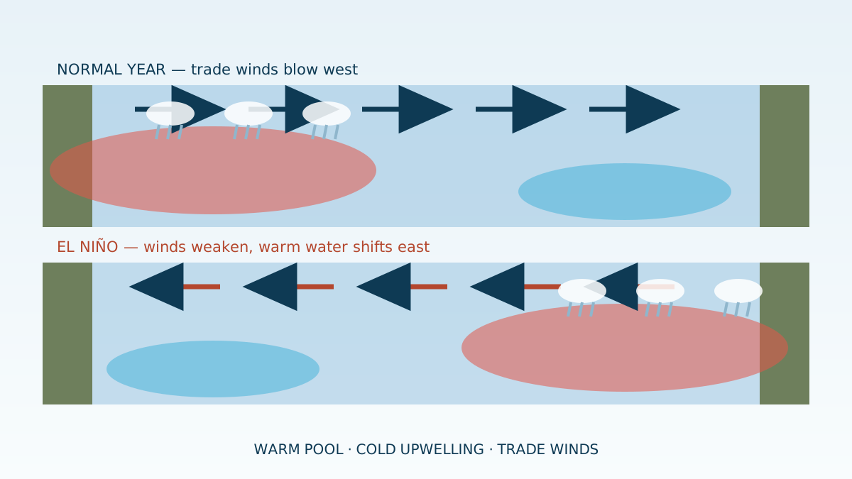
In ordinary years, trade winds blow steadily from east to west across the tropical Pacific, dragging warm surface water toward Asia and Australia. Warm water piles up in the west, thunderstorms build above it, and cold water rises along South America to replace what left — feeding one of the richest fisheries on Earth.
When the winds relax
During El Niño, those winds weaken or even reverse. Warm water sloshes back east, the cold upwelling off South America shuts down, and the rainclouds migrate with the warm pool. The result is a redistribution of weather: heavy rain and flooding on normally dry coasts, drought where rain is expected, and disrupted fishing where the nutrients stopped rising.
La Niña: the other swing
When the trade winds instead blow harder than usual, the Pacific swings the other way into La Niña: a cooler eastern ocean, stronger upwelling, and roughly opposite rainfall effects. Together the two phases form a cycle scientists call ENSO — the El Niño–Southern Oscillation — the single largest source of year-to-year climate variation on the planet.
Why forecasters watch it so closely
Because the ocean changes months before the weather does, ENSO is one of the few climate signals that can be forecast in advance. Agriculture ministries, insurers, energy planners and aid agencies all track it, since knowing which phase is coming turns an unpredictable year into a manageable one.
Conclusion
El Niño is not a storm or a disaster; it is a rearrangement of where the ocean keeps its heat. Learn to read that seesaw and a surprising amount of the world's weather stops looking random.
Frequently Asked Questions
What is El Niño?
A periodic warming of the central and eastern tropical Pacific that happens when trade winds weaken, shifting rainfall patterns across much of the world.
How often does El Niño happen?
Irregularly, roughly every two to seven years, usually peaking around the end of the calendar year and lasting several months.
What is La Niña?
The opposite phase, when trade winds strengthen and the eastern Pacific turns unusually cool, generally producing mirror-image weather effects.
Sources & Further Reading
Last updated: 6 August 2026